| |
Panama, recognized as the umbilical cord that united Central America with South America located in the middle of the American continent; borders north with the Caribbean Sea; south with Pacific Ocean; west with Costa Rica and east with Colombia. Its arch reflects its peculiarity in being a bridge between two continents and passage between two oceans.
Panama´s territorial surface is 75,517 square kilometers made up by a mountainous axis, former skeleton of a more wider territory submerged under water as witnessed by a number of islands in the Pacific coast (Coiba Island and the Las Perlas Archipelago) and the accidents in the Atlantic coast (Bocas del Toro Islands, Chiriquí Lagoon and the Gulf of San Blas).
The Azuero penninsula, which occupies a southern position, confirms the presence of a mountain range under the Pacific Ocean. From west to east you can find the Veraguas mountain range, an extension of the Talamanca in Costa Rica; and the San Blas and Serranía del Darién Mountains.
In the country´s western region the highest point is some 3 000 meters (Barú Volcano 3,374 meters). The highest point in the isthmus, Culebra Port in the Veraguas Mountain Range, only 87 meters high, allowed the opening of the Panama Canal. More to the east, there is another high point, but only reaches 2,000 meters.
Panama has the most accesable humid tropical forest in the world, its diverse national parks occupies 5 million acres and has the largest bio-diversity of forests, an indicator of this is the 944 species of bird.
Panama´s climate is tropical, with an unusual temperature of between 28 and 30 degrees throughout the year. The nights are generally cool. Panama has two seasons: rainy and dry, known as summer which begins in December and ends at the end of April. During this period nice winds blow the region.
Panama has coasts that take up a total of approximately 2,988.3 kilometers long. We must mention two types of coasts: Caribbean Sea and the Pacific Ocean. The Caribbean coasts has an extension of 1,287.7 kilometers and of them you can find strong winds and waves; while the coasts to the Pacific Ocean has an approximately 1,700.6 kilometers long.
Panama is a previleged nation due to its geographic position making the country multi-cultural and an international trading center considered as “Bridge of the World Heart of the Universe”. It is beautiful for its beaches with interesting sites and family recreational sites. Cultural and historic tours are offered during the year, which include: wildlife, botany, archeology, photography, bird watching, whales, walks, diving, butterfly watching, patron saints festivals, crossing the Panama Canal, excursions to tropical forests, colonial Panama, indigenous culture and much more.
Panama is a very special place, where you will discover wonderful sties that will surprise your imagination.
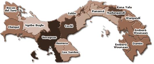
Panama is a country divided into 9 provinces, 74 districts, 594 corregimientos or small adminsitrative units and 5 Indigenous regions made up by: Kuna Yala, Ngöbé-Bugle, Emberá-Wounaán, Madungandí and Wargandí. Each province is divided into districts that make up the municipalities and then into smaller administrative units that are called corregimientos.

- Bocas del Toro: Its capital is Bocas del Toro, located in Colón Island.
- Chiriquí: Its capital is Davis and is divided into 13 districts and 91 administrative units.
- Coclé: Its capital is Penonomé and has 6 districts.
- Colón: Its capital is Colón and is divided into 5 districts.
- Darién: Its capital is la Palma. It is the largest province and less populated.
- Herrera: Its capital is Chitré and has 7 districts.
- Los Santos: Its capital is Las Tablas. It has 79 adminsitrative units and 7 districts.
- Panama´s: Its capital is Panama and has 11 districts and 97 administrative units.
- Veraguas: Its capital is Santiago and has 84 administrative units and 11 districts.
Panama has a total of 1,518 islands among the most important are: Coiba, Colón, Bastimentos, Del Rey, Contadora, San Jose, Boca Brava.
|
|